“Holy city Kyiv — stronghold of faith and hearth of piety in Eastern Europe… I am astonished by the learnedness, purity, and beauty of the local monastic life.”
JOHANN HERBINIUS“Ukraine, I found a most fertile field of excellent husbandry; and entirely different from the idea I had formed from the books which mention that country.”
JOSEPH MARSHALL“Ukraine is an exceptionally fertile country. Its fields yield bread, wine, honey, and livestock in quantities unmatched in other parts of Europe.”
GUILLAUME LE VASSEUR DE BEAUPLANIn the 17th century, not only did travelers from Western Europe discover Ukraine, but Ukrainians also discovered new lands for all of Europe. One of them, Mykhailo Boym from Lviv, became the first European to describe Chinese flora.
Mykhailo was born into a prominent merchant family that was part of the city council (their chapel remains a true Lviv landmark to this day). At the age of 14, the future traveler fell gravely ill, vowing that if he survived he would travel to Asia. He kept his promise. After recovering, he joined the Jesuit order and began preparing for a mission to the East. He studied philosophy, theology, and medicine.
The road to China lay through Africa, so on his way, Mykhailo visited Mozambique, where he made scientific sketches of the flora and fauna, including the first known European depiction of a hippopotamus. He traversed jungles, crossed a desert, escaped arrest, and was taken aboard a Chinese pirate ship. He covered part of the journey on foot, together with a Chinese companion.
In China, he created 18 maps depicting all the provinces of the empire. On these, he was the first to mark the Great Wall of China, the Gobi Desert, and the Korean peninsula (Europeans had previously considered it an island).
Mykhailo was the first European to describe the traditional Chinese calendar in detail, documenting its unique 60-year cycle, based on “heavenly stems and earthly branches.” Thanks to these works, Europe came to understand how years, months, days, and hours were counted in China.
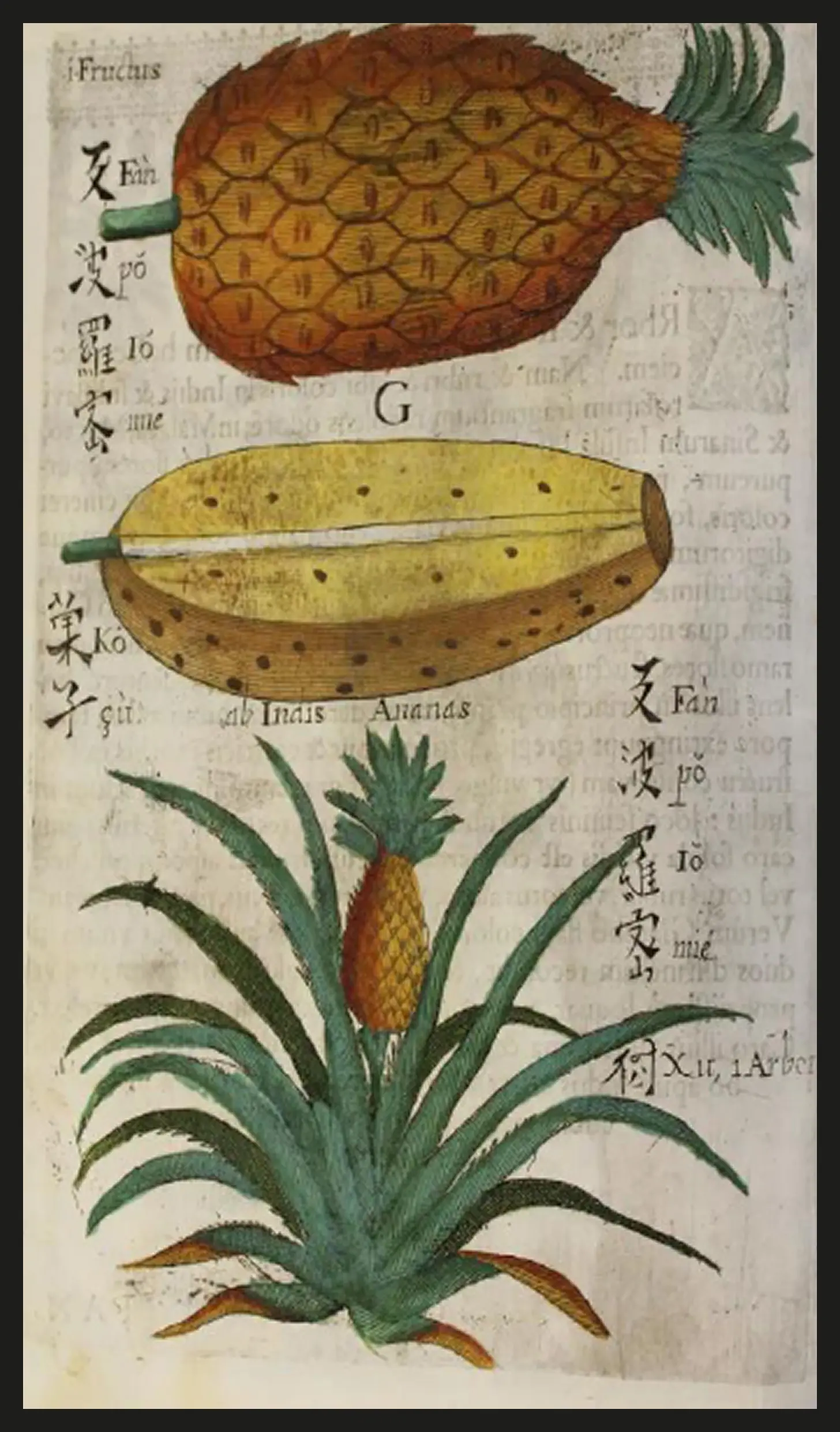
The main achievement of the Lviv native was Flora Sinensis, illustrations from which you see before you. The book was published in Vienna in 1656. It was the first European publication about Chinese plants and the first in history to use the word “flora” in its modern meaning.
On its pages, Mykhailo described more than 20 plants, previously unknown in Europe, including tea and pineapple shrubs, and mango trees. Each description was accompanied by its Latin name and medicinal properties, with detailed illustrations drawn by hand. He was also the first to bring kiwis to Europe.
Travels Through Holland, Flanders, Germany, Denmark, Sweden, Lapland, Russia, The Ukraine and Poland in the Years 1768, 1769 and 1770
Joseph Marshall was neither an ambassador, nor a spy, nor a soldier. He had no diplomatic status or political commission.
Yet it would be difficult to call him an ordinary Englishman: Marshall was an educated member of the British gentry who, in 1768–1770, undertook a Grand Tour — an educational journey through Europe customary for the British elite of the time. It was out of curiosity and a desire to see the world that he came to Ukraine, and upon returning, he published a book Travels through … Russia, the Ukraine and Poland (1772), which became a valuable source of knowledge about our lands from a European perspective.
In 1770 his route passed through Starodub, Chernihiv, Kyiv, and Ochakiv. Marshall had no preconceived notions about these places, and perhaps for this reason he saw more than those who viewed our land through the lens of empire.
He was the first English-language author to give a detailed description of Ukrainian domestic life: how people managed their households, what they built, and how they organized their everyday life. His journey was not merely a record of the route, but a deep immersion into space and culture.
Histoire de Charles XII, roi de Suède, 1731 —
The History of Charles XII, King of Sweden
УUkraine played a central role in Voltaire’s account of the Swedish king Charles XII. Why? Because during the Great Northern War, it was on Ukrainian soil that the decisive events of the 1708–1709 campaign unfolded — including the alliance of Charles XII with Hetman Ivan Mazepa and the Battle of Poltava.
And although Voltaire never visited the Ukraine of that time, he wrote about it with the meticulousness of a scholar and a journalist: he drew on the works of Beauplan, de Limiers, and Cantemir. Through his contacts with emigrants — above all with Hryhor Orlyk, the son of Hetman Pylyp Orlyk, as well as through Baron Friedrich Ernst von Fabrice and the Marquis de Maison — he learned about Mazepa’s plans and the Cossack struggle for independence. He also corresponded with eyewitnesses of the events, those who had personally known Charles XII or fought alongside him. Among his informants was, for example, Stanisław Leszczyński — the former Polish king who, like Mazepa, was an ally of the Swedes in the Great Northern War.
This was an important source that shaped the image of Ukraine in contemporary Europe, since Voltaire was read across the continent. It testified that in the 18th century Ukraine existed on the political map of the world as a distinct country. In his book, Voltaire never used the word “Russia” (la Russie), only “Muscovy” (la Moscovie), clearly separating it from Ukraine. This is especially significant given that it was only in 1721 that Tsar Peter I officially changed the name of his state from Muscovy to Russia, in an attempt to appropriate the legacy of Kyivan Rus. Voltaire, by contrast, gave Ukraine a precise geographical and political definition, never conflating it with Muscovy and treating it as a distinct power in European history.
A Discourse of the Original, Countrey, Manners, Government and Religion of the Cossacks, With another of the Precopian Tartars (1663)
Before you is a unique testimony about Ukraine in the mid-17th century, written not by a historian who studied in a library, but by an eyewitness and participant of the events. Pierre Chevalier, a French officer, diplomat, and adviser to the royal mint, came to our lands not as a researcher but as a commander.
There are reports that he had contacts with the Cossacks, whom the French government planned to recruit for service. During the Khmelnytsky period, Chevalier became the secretary of the French embassy in Warsaw.
Over ten years he gathered unique observations about the daily life, faith, government, and struggle of the Cossacks. This gave rise to his work The Cossack War Against Poland (1663), which consists of several parts, including A Discourse of the Original, Countrey, Manners, Government and Religion of the Cossacks. Importantly, Chevalier did not equate Ukrainians with Muscovites, but viewed them as a distinct people with their own land, language, and political ambitions.
His book became perhaps the only Western European chronicle of the time of Bohdan Khmelnytsky written by a contemporary, and for centuries it remained the main source for understanding Ukrainian Cossack statehood.
Religiosae Kijoviensis cryptae, sive Kijovia subterranea — The Sacred Kyiv Caves, or Subterranean Kyiv
1673. Religious conflicts rage in the heart of Europe, while empires battle for territory in the east. At the crossroads of these events, the German pastor and historian Johann Herbinius arrives in Kyiv.
His route took him through monasteries — places where not only faith, but also culture, was preserved. The Church carried out the role usually performed by the state: keeping memory, identity, and continuity alive in times without statehood — writes modern historian Yaroslav Hrytsak.
The Kyiv-Pechersk Lavra left the deepest impression on Herbinius. What he saw in Kyiv overturned his assumptions about these lands. He had expected to find something wild and neglected; instead, he discovered a world of deep spiritual tradition, highly educated monks, and an orderly daily life. The Kyiv Church revealed itself to him as a true center of European culture — not an object of missionary work, but a source of moral strength and knowledge.
Regni Poloniæ, Magnique Ducatus Lituaniæ: Omniumque regionum juri Polonico Subjectorum. Novissima Descriptio, 1659 — The Most Recent Description of the Kingdom of Poland and the Grand Duchy of Lithuania, and All Lands Subject to Polish Law
Imagine a map without borders — only rivers, cities, and lines connecting the space into something whole. This is how the mathematician and cartographer Andreas Cellarius saw Eastern Europe. In 1659, his work Regni Poloniae, Magnique Ducatus Lithuaniae… was published in Amsterdam, where he attempted to capture the complex political geography of the Polish–Lithuanian Commonwealth. And among other things, he clearly marked: “Ucrania.”
The marking of Ukraine (the second name in the long title of the map Regni Poloniae…) allows us to say that Cellarius not only outlined the term but established it as an independent entity on the political canvas — a shift from geography to politics, something few cartographers of his time dared to contest.
Cellarius placed Ukraine between the Dnipro and the Dniester. He brought it out from parentheses and shadows into a visible place. On the map appear Kyiv, Lviv, Kamianets and Chernihiv. Not just cities, but parts of a living political space that has a name and form. This map was not only a guide for Europeans of the seventeenth century. It still speaks of something essential: we have existed since long ago. With our own name, our own cities, our own history.
Description d'Ukranie, qui sont plusieurs provinces du Royaume de Pologne. Contenues depuis les confins de la Moscovie, iusques aux limites de la Transilvanie, 1651 — A Description of Ukraine, containing several Provinces of the Kingdom of Poland, Lying between the Confines of Muscovy, and the Borders of Transylvania
Before you is a unique object — the very first GPS navigator for Europe through our lands. Guillaume Le Vasseur de Beauplan’s map and book, published in 1648 and 1651, were so precise that for more than a century and a half, governments, armies, and travelers used them as the main source of knowledge about Ukrainian territories. These publications cemented the name Ukraine in European minds, not as something “on the borderlands,” but as a country with its own geography, people, customs, and military power.
Beauplan, a French engineer and cartographer, served the Polish king for 17 years. In 1630 he arrived in Ukraine and was struck by the boundless steppes, the freedom-loving Cossack spirit, and the extraordinary richness of the land.
As a military engineer in the army of the Polish–Lithuanian Commonwealth, he was tasked with strengthening fortifications in Brody, Bar, Pidhirtsi, Kremenchuk, Kodak, and Koniecpol. His mission was to fortify the southeastern frontier, which was constantly under attack from the Ottoman Empire and the Crimean Khanate. During his years of service, he studied the life, customs, and mentality of the Ukrainian people — and this experience became the basis for his work.
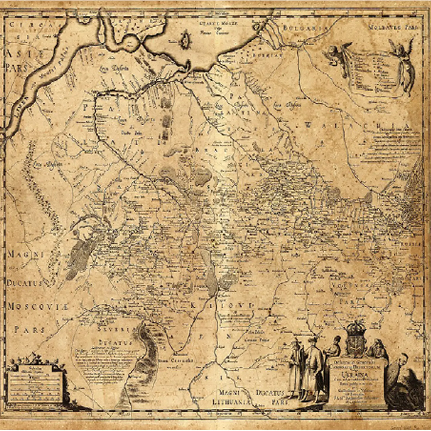
Beauplan created the most detailed map of Ukraine — the General Map of 1648 and 1650. On it, he united all of the Ukrainian regions for the first time: Chernihiv, Poltava, Zaporizhzhia, Podillia, Kyiv, and Galicia. Looking at them, you may feel disoriented — what is where? That is hardly surprising, since on Beauplan’s maps everything is reversed: the top is South, and the bottom is North.
ON THE WORLD MAP
Until the 15th century, cartographers labeled our land as Rus or Ruthenia. But starting in the mid-16th century, the name Ukraine began to appear more and more frequently on maps. Everyone who visited these territories noted the strength, hospitality, hard work, and free spirit of the people who lived here. They were called the finest farmers and mightiest warriors who knew how to defend what was theirs.
This room contains old prints and original editions. Some of them are 300 years old. Some, even older. Some came from museums, and some were purchased abroad from private collectors to help us better understand ourselves.
Discover how Beauplan, Voltaire, Chevalier, Marshall, Herbinius, and Cellarius depicted our land.
YOU FROM?